 Washington
Washington
Washington
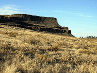
Rising 800 feet above the waters of Banks Lake like the prow of a colossal ship, Steamboat Rock is a massive basalt butte that stood as an island in the middle of the raging floodwaters that carved the Grand Coulee. This flat-topped mesa...
Narrated audio coming soon · full transcript below
Steamboat Rock is an 800 foot basalt butte standing alone in the middle of the Grand Coulee, and the easiest way to understand it is to picture what is missing. Everything around this rock used to be solid ground.
When the Missoula Floods, rerouted south by a wall of ice blocking the Columbia, came tearing through here, they scoured the Grand Coulee down to bedrock and hauled the debris toward the sea. Steamboat Rock is the piece they could not move. A more resistant slab of Columbia River basalt, it split the floodwaters and stood while the canyon was gouged out around it on every side.
Climb the trail to the top and you are standing on a fragment of the original land surface, left marooned 800 feet in the air. The flat water at its base, Banks Lake, is a modern reservoir, but the shape of the coulee around it is pure flood.
Why it matters: erosion usually subtracts a little at a time, too slowly to watch. Here you can measure exactly how much was removed, because one stubborn island was left behind to mark the old ground level.
Bring this stop into the classroom: NPS “Investigating Ice Age Floods” Teacher’s Guide →
Rising 800 feet above the waters of Banks Lake like the prow of a colossal ship, Steamboat Rock is a massive basalt butte that stood as an island in the middle of the raging floodwaters that carved the Grand Coulee. This flat-topped mesa of Columbia River basalt survived because it was simply too massive for even the Missoula Floods to destroy, though the floods stripped away everything around it, carving the Grand Coulee deeper and wider with each successive event. The butte's summit covers 600 acres -- large enough to hold a small town -- and provides sweeping 360-degree views of the coulee walls, Banks Lake, and the surrounding scabland terrain. Floodwaters once surged around both sides of the rock at depths of hundreds of feet, polishing its flanks and depositing enormous gravel bars in its wake. Today Steamboat Rock State Park offers camping, swimming, and hiking, including a trail to the summit that rewards with one of the most dramatic panoramas in all of Washington state. Standing on top, surrounded by the sheer walls of the Grand Coulee, you grasp the staggering scale of the floods that carved this landscape.
Steamboat Rock is a 3,522-acre park near Electric City, Washington, on the shore of Banks Lake in Upper Grand Coulee. Open daily 8 a.m. to dusk year-round; the park has 136 campsites with hookups (reservable April 1–Oct 31; first-come-first-served otherwise). Discover Pass required for day use. The summit trail to the top of the 800-foot butte gains roughly 800 feet over 2.5 miles round trip.
Steamboat Rock is one of the signature flood-erosion landforms on the trail. The 800-foot basalt butte is a remnant left after Missoula floodwaters scoured the surrounding bedrock in Upper Grand Coulee, where torrents poured over what was once an upper cataract roughly twice the height of Dry Falls. Floodwaters in Upper Grand Coulee at peak discharge were on the order of hundreds of feet deep and stripped the basalt down to the underlying granitic basement in places, a contact that is visible from the trails around the butte's base. Steamboat Rock survived because flow split around it, while the cataract face retreated upstream until it stranded the rock as an island in a dry channel. The largest floods, anchored by Balbas et al. (2017) cosmogenic dating at 18.2 ka, are responsible for much of the sculpting visible today.
The 10Be cosmogenic work by Balbas et al. (2017) and subsequent USGS reviews refined the timing of Upper Grand Coulee flood activity, with the coulee opening fully as a flood route after about 15.6 ± 1.3 ka. No newer park-specific publications located.
The Lower Grand Coulee Chapter (Soap Lake/Ephrata) treats Steamboat Rock as one of its featured field-trip destinations; IAFI hosts a dedicated page on the rock. No on-site IAFI-branded interpretive panel located, but the park itself maintains geologic signage near the trailhead.
April–October is the prime window for the summit hike and water recreation on Banks Lake; the rim trail offers the best perspective on the surrounding coulee walls and the granitic-basalt contact. Pair with Dry Falls and Sun Lakes for a full Upper Coulee day.
Flood-extent overlay shows the maximum reach of the Missoula Floods.
The site in its place along the flood path, with the maximum flood extent drawn over the modern map.
View on the interactive map Searchable sites · 360° trails · flood reconstruction