 Washington
Washington
Washington
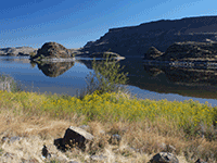
Tucked into the basalt walls of the lower Grand Coulee, the Lake Lenore Caves were literally ripped from solid rock by the Missoula Floods. As floodwaters crashed down the coulee, they selectively eroded softer layers within the basalt...
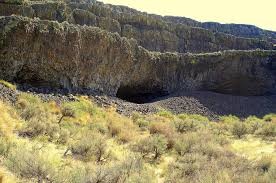
Tucked into the basalt walls of the lower Grand Coulee, the Lake Lenore Caves were literally ripped from solid rock by the Missoula Floods. As floodwaters crashed down the coulee, they selectively eroded softer layers within the basalt cliff faces, pulling chunks of rock from the walls and creating shallow but spacious caverns. The caves' walls expose the Grande Ronde and Wanapum basalt flows in spectacular cross-section, with visible colonnade and entablature cooling patterns in the ancient lava. For at least 5,000 years after the floods, Native American hunters and gatherers used these caves as temporary camps and storage sites, drawn by the shelter from wind and weather and the easy access provided by post-flood talus slopes. The caves are still used for certain Native American religious ceremonies today. A well-marked 1.2-mile out-and-back trail leads from the parking area to the caves, passing through terrain shaped entirely by the floods. Inside the caves, it is cool and calm even on the hottest days, and the depth provides shelter while allowing light to reach every corner. These are among the most accessible flood-carved features on the entire trail.
Open year-round; Lake Lenore Caves State Park Heritage Site (Washington State Parks). Day-use only, Discover Pass required ($10/day or $30 annual). Located on SR 17 between Soap Lake and Coulee City in the Lower Grand Coulee. Trailhead has restrooms and parking.
The caves are flood-quarried basalt alcoves in the east wall of Lower Grand Coulee. As Missoula floodwaters poured through the coulee, after spilling over Dry Falls a few miles north, extreme hydraulic pressure plucked columnar basalt out of the cliff in irregular pockets, leaving shallow recesses 10–30 feet deep. The caves are not solutional (no limestone), nor lava-tube (no flow features inside); they are pure mechanical-erosion features. Post-flood weathering produced talus aprons that gave easy access from the coulee floor; archaeological evidence shows Native use for at least 5,000 years as temporary camps and storage. The Lower Grand Coulee floor sits roughly 800 feet below the surrounding plateau; the caves are 200–400 feet above the lake on the east wall.
No site-specific updates since Bjornstad's On the Trail of the Ice Age Floods coverage and the Balbas et al. (2017) cataract-retreat dating for Upper Grand Coulee, which constrains the timing of the floodwater pulses that did this scour. Lake Lenore itself is a Holocene playa pond on the coulee floor.
The Wenatchee Valley Erratics Chapter and the Cheney-Spokane Chapter both include Lake Lenore Caves on their Grand Coulee field-trip rotations. Washington State Parks interpretive signage at the trailhead covers the flood origin clearly.
Best March through May (cooler, wildflowers) and October. The trail to the lower caves is a 1-mile round trip with one short steep section; upper caves require off-trail scrambling. Watch for rattlesnakes May–September. The coulee walls catch afternoon light well, late afternoon is the best photography window.
Tucked into the Lenore Canyon are the Lake Lenore Caves. Along with much of the eastern half of the state, Lenore Canyon was formed during the Missoula floods at the end of the last Ice Age, over 13,000 years ago. The glacial flood waters crashed down the canyon, carving through the basalt that makes up the sheer rock walls, creating coulees, ridges, cliffs, plateaus, rock slides, caves and a series of lakes.
The caves themselves are shallow, created during the Great Missoula flood as water pulled chunks of basalt from the walls of the coulee. Post-flood weathering created talus slopes that furnished easy access and temporary overnight camps and storage for at least 5,000 years for hunters and gatherers from villages located elsewhere in the Grand Coulee and along the Columbia River and its tributaries. It is still used today for certain Native American religious ceremonies. It is easy to see why the caves were chosen as a cozy place to stay, as the depth provided plenty of shelter from the elements, while not going so deep that light couldn’t reach the back corners. It is often quite warm and breezy outside, but in the caves it is cool and calm.
A well-marked 1.2-mile out-and-back trail leads from the parking area to some of the caves. It is generally considered an easy route that takes an average of 31 min to complete. This is a popular trail for hiking and walking, but you can still enjoy some solitude during quieter times of day. The best times to visit this trail are March through November. Dogs are welcome, but must be on a leash.
The coulee walls in this area are made up of Grande Ronde Basalt flows overlain by the Frenchman Springs and Roza members of the Wanapum Basalt. The lower (colonnade) and upper (entablature) cooling units of individual flows are visible in the coulee walls. Flow unit contacts are sometimes complex to interpret. Some flows pinch out against older flows, some are perhaps due to flows covering an irregular topographic surface on t


Flood-extent overlay shows the maximum reach of the Missoula Floods.
The site in its place along the flood path, with the maximum flood extent drawn over the modern map.
View on the interactive map Searchable sites · 360° trails · flood reconstruction