 Washington
Washington
Washington
The southern terminus of the Columbia Plateau Trail near Pasco brings travelers to the confluence zone where multiple scabland flood channels merged before funneling through Wallula Gap. After traversing 130 miles of the Cheney-Palouse...
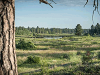
The southern terminus of the Columbia Plateau Trail near Pasco brings travelers to the confluence zone where multiple scabland flood channels merged before funneling through Wallula Gap. After traversing 130 miles of the Cheney-Palouse scabland tract, the trail ends at the edge of the Pasco Basin -- the enormous bowl where floodwaters collected when the Wallula Gap bottleneck could not drain them fast enough, creating temporary Glacial Lake Lewis. The terrain here transitions from the rugged basalt channels of the scablands into the fine-grained lake sediments deposited by the standing water, a visible geological boundary you can trace along the trail. These rhythmite deposits -- alternating layers of silt and sand from successive flood events -- record dozens of separate megaflood cycles in their layered structure. The trail's southern end offers a perspective that complements the northern section: where the north shows the floods' erosive power, the south shows their depositional aftermath, where billions of tons of sediment settled in temporary lakes. Together, the two ends of this trail tell the complete story of destruction and deposition.
The south end of the Columbia Plateau Trail runs from Snake River Junction Trailhead (north of Pasco) along the Snake River to Ice Harbor Dam, about 15 miles of developed surface. The Snake River Junction Trailhead is the primary access; signage and parking are basic. Discover Pass required at staging areas. The connector to Sacajawea State Park (Columbia–Snake confluence) is at the southern end. Year-round; summer heat at this low desert elevation is severe.
The southern segment of the trail crosses some of the most visible flood-erosion features in the Channeled Scabland. The trail passes the point where the Palouse River was captured by flood erosion and diverted away from its former course (the now-dry Washtucna Coulee); Washtucna Coulee itself, a wide, dry, basalt-walled valley, is the abandoned course scoured wide by Missoula waters. Devil's Canyon, also on the trail, is a slot cut by overtopping flood water through basalt. Lower-elevation reaches of the trail near the Snake River show giant current ripples and gravel bars deposited as flood discharge slowed where it spread into the broader Snake-Columbia channel.
Balbas et al. (2017) anchored the regional chronology; flood-pathway geomorphology around Washtucna Coulee and Devil's Canyon is treated in the O'Connor et al. (2020) USGS review.
The southern end falls within the IAFI Palouse Falls Chapter's coverage (western Whitman, northern Franklin, and all of Adams counties). The Palouse Falls Chapter regularly leads flood-geology field trips in this corridor.
Best October through April; summers are brutally hot (often 100°F+) and shadeless. Bicycles are the practical way to cover meaningful distance. Pair with Palouse Falls State Park (~50 miles east) and Sacajawea State Park at the trail's southern terminus.
Flood-extent overlay shows the maximum reach of the Missoula Floods.
The site in its place along the flood path, with the maximum flood extent drawn over the modern map.
View on the interactive map Searchable sites · 360° trails · flood reconstruction