 Washington
Washington
Washington
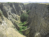
A man-made irrigation ditch near Walla Walla accidentally exposed one of the most scientifically important geological cross-sections on the Ice Age Floods trail. When farmers cut Burlingame Canyon in 1926, they revealed layer upon layer of...
A man-made irrigation ditch near Walla Walla accidentally exposed one of the most scientifically important geological cross-sections on the Ice Age Floods trail. When farmers cut Burlingame Canyon in 1926, they revealed layer upon layer of rhythmites -- alternating bands of silt and sand that record individual Missoula Flood events stacked atop one another like pages in a book. Geologists have counted up to 40 distinct rhythmite layers here, each one representing a separate catastrophic flood that swept through the area, deposited a layer of sediment, and receded. Between many of the flood layers, thin soil horizons and even ancient insect burrows indicate periods of decades between successive floods -- critical evidence that the flooding was not a single event but a repeating cycle over roughly 2,500 years. The rhythmites at Burlingame Canyon helped settle one of geology's great debates by proving that J Harlen Bretz was correct about multiple catastrophic floods but also that his critics were right that there was more than one event. Though on private land, this site remains one of the most cited geological exposures in Missoula Floods research worldwide.
Burlingame Canyon is on private land southwest of the town of Touchet, near the Touchet–Walla Walla River confluence in Walla Walla County, Washington. It is posted, fenced, and not open to public visitation; the cliffs are unstable and the area is explicitly off-limits for liability and safety reasons. Permission to access for organized academic or interpretive groups is rare and arranged in advance through the landowner. Treat this site as a "read-about, do not visit" location for the public-facing page.
Burlingame Canyon is arguably the most important single outcrop in the Missoula-flood story. In 1926 an irrigation-ditch breach scoured a 1,500-foot-long, ~100-foot-deep gash that exposed the full Touchet Formation in cross-section. Within those walls, Richard Waitt counted ~40 distinct rhythmite layers (alternating graded sand, silt, and clay), the evidence that drove the 1980s consensus shift from one Bretz flood to dozens of separate Missoula outburst floods. Each rhythmite records one backflood pulse ponded behind Wallula Gap; the included Mount St. Helens "set S" tephra in one bed and rodent burrows / soil cracks between beds anchored the multi-flood interpretation.
The Waitt (1980, 1985) interpretation remains the standard. Shaw's hyperconcentrated-flow alternative (proposing rhythmites as pulses within a single mega-flood) has not displaced it. No new rhythmite-focused work at Burlingame published since 2017; Balbas et al. (2017) chronology (~18.2 ± 1.5 ka for largest events) is the regional anchor.
Burlingame is regularly cited in IAFI educational materials and Lake Lewis / Palouse Falls Chapter content, but no IAFI interpretive presence exists on the ground because of the private-property restriction. Whitman College in Walla Walla holds related Touchet Formation collections.
Not visitable. For the same rhythmite story in an accessible location, send visitors to roadcut exposures along US-12 east of Touchet or to the Touchet Formation outcrops at Walla Walla's Mill Creek.
Flood-extent overlay shows the maximum reach of the Missoula Floods.
The site in its place along the flood path, with the maximum flood extent drawn over the modern map.
View on the interactive map Searchable sites · 360° trails · flood reconstruction